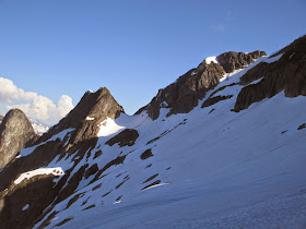
The Northeast Ridge is a reasonable route to the summit. It's only about 5.6, but that doesn't mean any of the climbing on the route should be taken for granted. It is a full-on alpine experience that includes some loose and scratchy rock, some moss and giant snow blocks. The mountain is not that far back, but the approach is extremely physical.
Though the route can be done in two days, it is a far more comfortable ascent in three...
Here's a write-up on the mountain from Summitpost.org:
Mt. Triumph is an important mountain in North Cascades National Park. It is located about six miles WNW of the town of Newhalem, WA. It lies entirely within the Skagit River drainage. The peak is not as high as a lot of the other important peaks of the park, yet it possesses just as much chutzpah. Certainly, on the whole, it is more precipitous than most of those peaks. You can see the very top of the peak from Marblemount as it rises over the nearer summit of Oakes Peak. This extra rise hints at its prominence above peaks immediately to the south. Mt. Triumph is connected via Triumph Pass to a slightly higher Mt. Despair--an aptly named tandem if their ever was one. Although Despair is an easier climb than Triumph (at least in terms of the climbing on the mountain itself; Despair requires a longer approach) maybe the peaks should be named in reverse. But then, one feels triumphant to have climbed Triumph, for there is no easy way up it.
Yes, Mt. Triumph is characterized by verticality and sharpness. It is rugged on all flanks. On a topo or from directly overhead, the peak has the appearance of a three-bladed propeller. Evenly spaced Northeast, Northwest, and South Ridges divide evenly spaced East, North, and West Faces. The mountain cradles two rapidly declining glaciers below the East and North Faces. In particular, the eastside glacier is very sickly. It is much reduced from that depicted on topographic maps. A veritable pool table slate of slabs below the glacier makes for quite the tumbling ground for billiard cubes of ice excising themselves from the glacier's lower terminus. The northside glacier isn't faring much better. On both of these we often heard blocks of ice careening down the slabs.
A note about the name: Triumph was named by Lage Wernstedt, the famous surveyor of the North Cascades (namely, in the Pasayten region) in the early part of the 20th Century. In addition, Wernstedt was responsible for the naming of Mt. Despair, Mt. Fury, Mt. Terror, Mt. Challenger, Inspiration Peak, and the "Picket Range." It should be noted that Wernstedt did not climb any of these peaks. Information courtesy of Harry Majors.
Following is a photo essay from a recent ascent of Mt. Triumph:
The approach passes by a series of beautiful alpine lakes.
The approach is very physical.
Camping options are at the top of the pass shown in the picture.
Mt. Triumph: The Northeast Ridge is the right-hand skyline.
The final approach to the ridge requires a traverse across steep snow.
The Southern Picket Range
Mt. Triumph
Looking back at the col where most people camp.
Climbing the Northeast Ridge
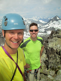
The obligatory summit selfie.
Looking back at Triumph on the way out.
--Jason D. Martin


No comments:
Post a Comment
Thank you for your comment. An administrator will post your comment after he/she moderates it.