Tuesday, November 25, 2008
Red Rock Geology
The Red Rock Canyon National Conservation Area has a unique geological history. Throughout the vast majority of recent geologic history (the last 600 million years), Red Rock was underwater, a part of a massive inland sea. During this period -- known as the Paleozoic Era -- sediments settled at the bottom of the sea and ultimately turned into limestone.
Approximately 225 million years ago, the earth beneath the sea began to rise. As sea-bed sediments became exposed to the air they quickly oxidized. The oxidization is what was responsible for the red and orange hue found throughout the canyon. Indeed, there are places where one can see rust stains still spreading in the sandstone.
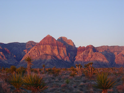
Throughout this period things continued to change. Over the years the area evolved into a broad plain. Approximately 180 million years ago the shift from sea to dry plain was complete. The area changed into a massive arid desert with mile-high shifting red sand-dunes. The limestone created by the sea still existed, it was just buried somewhere beneath the dunes. Over time these sand-dunes froze into a petrified state, creating the massive cliffs that now comprise Red Rock Canyon.
Some geologists believe that the striations that exist throughout the canyon are the result of shifting sand on top of petrified rock. The lines were simply created by the wind blowing sand across the desert in a variety of different directions.
Beginning approximately 65 million years ago, the earth's crust was again changing the area. A massive series of thrust faults which extended throughout the west developed. This caused an unusual thing to happen in Red Rock Canyon. Older limestone layers of rock were thrust to the surface and pressed over the younger layers of rock. One can easily see this in Red Rock today. The limestone is on top of the sandstone. This particular feature is called the Keystone Thrust.
Red Rock Canyon remains one of the only places in the world where there is easy access to such a thrust. As a result, university geology classes from all over the country make trips to Las Vegas in order to look at, study and map the thrust. We suspect that they probably map the Las Vegas Strip during their free time as well.
Geologic history is always intriguing. At AAI we often look at glaciers, volcanoes and valleys that were formed by geologic events. But for many guides the most interesting geology that we encounter is not that of the high mountains, but that of the beautiful and every changing desert of Red Rock Canyon.
--Jason D. Martin
Subscribe to:
Post Comments (Atom)


No comments:
Post a Comment